


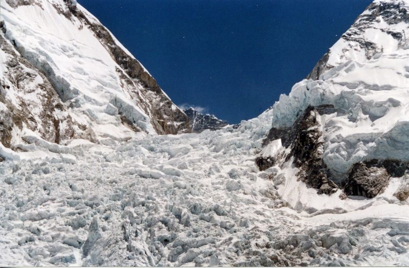
The Khumbu Icefall on Mt. Everest – Earth’s highest mountain above sea level – has a reputation for being especially dangerous. It’s a climb of some 3,300 feet (1,000 meters) in elevation gain, mostly through a landscape full of crevasses, large pillars and ice walls. And it’s moving. On September 17, 2020, the European Space Agency (ESA) described a new technique used by researchers from the University of Oslo in Norway to extract detailed information about the flow of this icefall, using data from the Copernicus Sentinel-2 satellite mission. The goal, ESA said, is:
… a reliable and consistent glacier mapping instrument which helps climbers ascend Mount Everest.
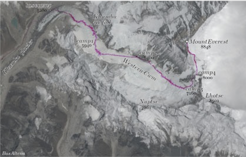
When high altitude mountaineers want to climb Mount Everest from the Nepalese side, they follow a route over and along Khumbu Glacier. Part of the glacier, the icefall, runs over a steep cliff, making it extremely dangerous.
At lower elevations, it is covered with debris. Around Everest basecamp, the glacier of Khumbu starts to receive clean, bluish ice that stems from snow and ice from Western Cwm, the highest glacier in the world.
Luckily, ESA said, trained Nepali workers known as icefall doctors have the know-how to create a path through this turbulent environment.
ESA explained:
Every year before the climbing season starts, they explore routes and lay ropes along them, placing aluminum ladders over the crevasses. The icefall is constantly moving, so throughout the climbing season crevasses open and close. Consequently, the team of ice doctors stays in Everest basecamp to be able to maintain the route through the icefall and re-secure ladders and ropes.
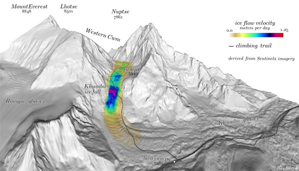
Crevasses on a glacier originate when a certain shear strength is reached (when there is a difference in velocity). Thus, in general, the faster ice flow in the middle of a glacier will generate crevasses on its sides, but when the flow over the whole glacier surface is known, these regions can be mapped accordingly.
The velocity pattern can thus be used to map dangerous areas on a glacier. Use of satellites for this purpose is evident, as these regions are very dangerous to access.
Fortunately, it is possible to observe glacier flow from space. But over the fast moving icefall of Khumbu glacier this had not been possible yet, because the glacier ice funnels through a narrow corridor of rock, causing disorderly fracture ice to flow downward and making feature tracking difficult.
Thanks to the large dataset from the Copernicus Sentinel-2 mission, the researchers used a novel image matching technique, called ensemble matching, to generate a detailed high-resolution velocity map of glacier velocity, despite challenging image conditions.
Thanks to a large collection of data from the Sentinel-2 satellites of the European Union’s Copernicus Programme, the researchers extracted the detailed flow field of Khumbu icefall.
Bas Altena, lead author of the study and researcher at University of Oslo, found this specific application. He said:
We used multiple optical imagery altogether, taking advantage of the high repeat rate of Copernicus Sentinel-2. This mission with two satellites in orbit can already generate detailed time-series of glacier velocity for large glaciers, but for smaller and fast flowing sections the current algorithms are challenged.
Our approach can provide solutions to these demanding situations, enhancing the capabilities of Copernicus Sentinel-2 towards a reliable and consistent glacier mapping instrument, with operational performance.
We hope that our results, be it little, can be of help to the ice doctors for managing the route through the icefall.

Bottom line: Satellite data from ESA’s Copernicus Sentinel-2 helps climbers navigate a treacherous icefall on their way to the summit of Mt. Everest.
Like what you read?
Subscribe and receive daily news delivered to your inbox.
More from
Deborah Byrd


