


Hurricanes need warm water to form, and that’s why the North Atlantic’s hurricane season begins on June 1 each year and runs through late November. But on January 14, 2016, a tropical depression in the eastern Atlantic evolved into a hurricane, which was given the first name on 2016’s list of hurricane names: Alex.
It became the earliest hurricane in the basin since 1938 and only the fourth January hurricane in the North Atlantic in 150 years of record-keeping.
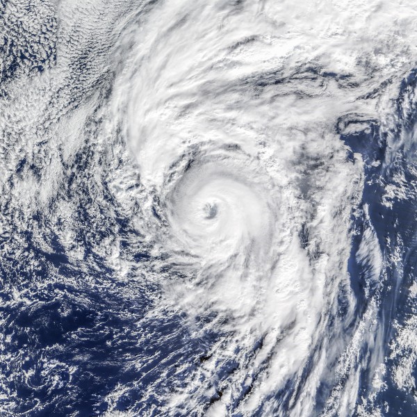
NASA Earth Observatory ran this image of Alex as its image of the day on January 15. NASA’s Terra satellite had acquired the image the day before, when the storm was about 500 miles (800 km) south of the Azores. NASA said:
Just days after Hurricane Pali became the earliest Central Pacific hurricane on record, the Atlantic basin spun up its own unusual storm …
Alex is not just unusual for being a hurricane in the dead of winter; it is also unusual as just the second storm on record to form so far north and east in the Atlantic (north of 30 degrees North latitude, east of 30 degrees West longitude).
The map below shows the track of Alex relative to the tracks of all reported storms in NOAA’s record from 1842 to 2015:

NASA said Alex formed when sea surface temperatures in the North Atlantic were about 0.5 to 1.0 degrees above normal for this time of year, at roughly 71 degrees Fahrenheit (22 degrees Celsius). Hurricanes typically don’t form until sea surface temperatures hit at least 78.8 degrees F. (26° C.).
A NASA meteorologist said a a low-pressure trough in the upper atmosphere caused cool air relative to the water below, which created a convective instability that ultimately spawned a hurricane.
Bottom line: January 14, 2016, satellite image of Hurricane Alex, this year’s winter hurricane in the North Atlantic.
Like what you read?
Subscribe and receive daily news delivered to your inbox.
More from
Deborah Byrd


